Geochemical elements and soil fertility in Kwara State: The role of parent materials, topography, and land use
Abstract
This study explores the soil nutrient status, geochemical composition, and fertility characteristics across Kwara State, Nigeria, to support sustainable soil management amid climate change challenges. A total of 266 soil samples were systematically collected using a uniform rigid grid sampling method and analysed through standard laboratory procedures. Statistical and geostatistical analyses, including descriptive statistics, interpolation, hierarchical clustering, and correlation analysis, were employed to examine spatial variability and interrelationships among soil properties. The results revealed mean and median soil pH values of 6.63 and 6.8, indicating moderately acidic to neutral conditions suitable for most crops. Soil organic carbon (SOC) levels were moderate, averaging 2.19%, suggesting fair organic matter content. Correlation analysis identified soil texture, organic matter, and pH as key determinants of nutrient availability. Linear discriminant analysis (LDA) further showed that variations in soil parent material, land use, and topography were primarily governed by particle size distribution, pH, and potassium (K⁺) concentration. Sandy soils exhibited higher pH levels, promoting base cation availability but limiting certain micronutrients, while clay-rich soils demonstrated stronger nitrogen retention. Overall, organic matter was found to be vital for maintaining soil fertility. These findings provide essential guidance for developing site-specific soil management practices to improve agricultural productivity and sustainability in Kwara State.
Introduction
Soils play a fundamental role in regulating environmental processes, acting as both geochemical sinks and buffers that mediate the movement of chemical elements across the atmosphere, hydrosphere, and biosphere (Qi et al., 2009; Liu et al., 2018). Understanding the spatial distribution and concentration of geochemical elements in near-surface soils is critical for assessing agricultural productivity, environmental health, water quality, land-use planning, and industrial pollution control. Soil geochemistry is primarily influenced by the mineralogical and chemical composition of its parent material (Chen et al., 2008), but topography and land-use practices also play significant roles in shaping soil fertility and elemental variability.
Geochemical elements in soils originate largely from the weathering of parent materials and are modified by pedogenic processes. However, anthropogenic activities such as agriculture, mining, and urbanization can significantly alter the natural geochemical landscape, often resulting in the accumulation of heavy metals and other pollutants (Padarian et al., 2022; Gayan et al., 2023; Hartmann and Six, 2023). The interaction between natural and human-induced factors determines soil fertility and elemental bioavailability, which are crucial for sustaining plant growth, livestock quality, and food security (Edwin and Muthu, 2021). Establishing background concentrations of soil geochemical elements provides a baseline for distinguishing between natural enrichment and contamination.
Topography influences soil formation and element distribution by affecting erosion, leaching, and water retention patterns. In undisturbed ecosystems, soil trace element concentrations reflect parent material composition and environmental conditions, whereas in cultivated landscapes, fertilizers, pesticides, and agrochemicals introduce additional elemental inputs (Wiesmeier et al., 2019). The intensification of agriculture, driven by population growth and rising food demand, has led to concerns about soil degradation and heavy metal accumulation, which can disrupt soil biological functions and pose risks to human and animal health through food chain contamination (Alloway, 1990; Miner, 2020).
This study investigates the spatial variability of soil textural, macro- and micronutrients across different geological formations and ecological regions of Kwara State, Nigeria. Given the region's diverse geology, climate, and land-use practices, we hypothesize that soil fertility and elemental distribution are primarily driven by parent material characteristics, modified by topographic influences and anthropogenic activities. By providing baseline data on soil geochemistry, this research aims to support sustainable land management strategies that enhance agricultural productivity while mitigating environmental risks.
Material and Methods
The study area
The study area encompasses Kwara State in Nigeria's north-central geopolitical zone (Fig. 1). The State is known for its unique ecological landscapes, diverse geological features, and significant agricultural activities, making it an ideal location for examining the impact of bedrock materials, land use, and topography on soil properties. Kwara State has a broad range of ecological zones, from the West Sudanian Savanna to the Guinean Forest-Savanna Mosaic, and even Montane Forests in the north eastern corner. Kwara's geographical coordinates lie between latitudes 8°30' and 11°30' North of the Equator and longitudes 3°E to 6°30' East of the Greenwich Meridian, covering approximately 36,825 square kilometres and divided into sixteen (16) Local Government Areas (LGAs) (Kwara State Government, 2024) (Fig. 2). The state's topography includes extensive savannas, forested highlands, and several rivers, such as the Niger and Awun, providing water for irrigation and domestic use. Kwara's unique vegetation zones foster a variety of crops and support diverse wildlife. However, the state also contends with ecological issues like soil erosion and deforestation, necessitating sustainable land management practices.
The State has a tropical savanna climate that feature distinct wet and dry seasons. It receives annual precipitation between 1,200 mm in the south and 1,000 mm in the north. Agriculture is the backbone of the state's economy, with production of staple crops like yams, cassava, maize, rice, and significant livestock production (National Bureau of Statistics, 2023). Atmospheric temperature is uniformly high and ranges between 25 °C and 30 °C in the wet season; throughout the season except between July and August when clouding of the sky prevents direct insolation. Dry season temperature ranges between 33 to 34°C. Relative humidity in the wet season is between 75 to 80% while in the dry season it is about 65% (National Bureau of Statistics, 2023). The climate supports tall grasses interspersed with short scattered trees. The soils are formed majorly from basement complex rocks (metamorphic and igneous rocks) covering about 95% of the area, and sedimentary rock along the Niger River bank covering about 5% of the total area (Fig. 1). The metamorphic rocks include biotite gneiss, banded gneiss, quartzite augite gneiss and granitic gneiss. The intrusive rock includes pegmatite and vein quartz (FDALR, 1990).
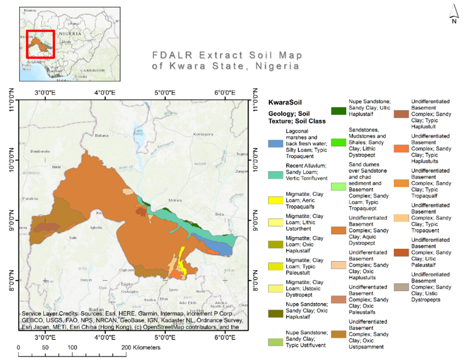
Fig. 1. Map of Kwara State showing the Federal Department of Agricultural Land Resources (FDALR) extract soil map of the state, in

Fig. 2: A: Kwara State local government areas; B: Soil parent materials in the study area; C: Topography of the study
Field survey
This study employed a combination of remote sensing and geographic information system (GIS) to aid systematic ground-truthing and field sampling in the study area. The satellite data utilized were 5-meter resolution SPOT 5and the 30-meter resolution Landsat 8 ETM+ imageries resampled to 15 m using the panchromatic band. Landform information was derived from 30-meter resolution Terra Advanced Spaceborne Thermal Emission and Reflection Radiometer (ASTER) Global Digital Elevation Model (GDEM) Version 3 (ASTGTM). Land use data was sourced from the Vegetation and Land Use Project of the Forestry Management Evaluation and Coordinating Unit (FORMECU), 2025 under the Nigerian Federal Ministry of Environment. Digital geological data was obtained from geological maps produced by the Federal Geological Survey of Nigeria (Federal Ministry Mines and Steel Development, Nigeria, 2025). Fieldwork involved systematic soil sampling for surface soil fertility analysis. Samples were collected at predetermined intervals across the study area using a rigid-grid sampling approach at a 10.6 km grid interval. All processing was done in the ArcGIS environment. Predetermined sampling points falling within highly urban areas and inaccessible points were excluded from the sampling process, and a total of 266 samples were collected.
In the field, sampling points were located using GPS-enabled handheld Android devices (phones/tablets). At each point, the soil was assessed using an orchard auger to a depth of 100 cm, and top soil samples were collected for the 0 - 30 cm depth. Sampling point characteristics were described in situ and recorded using the ODK software, which enabled real-time data transmission to a cloud-based database. Key physical and morphological characteristics assessed for each sample included soil colour, texture, structure, consistency, effective depth, stoniness, drainage status, and any included material - topographic, land use, erosion, and deposition characteristics were also recorded in-situ.
Photographs of the landscape and soil profiles were captured and stored using the ODK. For each sample, machine-readable QR codes were generated as a digital label, ensuring an efficient tracking of samples from the field to the laboratory for analysis and subsequent data storage. A composite of 3 samples was collected at each point using a modified African Soil Information Service (AfSIS) protocol (Walsh, 2023). Soils were sampled off-season in 2022.
Laboratory and Data analysis
Soil samples were air-driedand sieved to remove materials larger than 2 mm. The less than 2 mm portions were used to determine the physico-chemical properties of the soils. Soil pH was determined in 1:2.5 soil/water suspensions while organic carbon was determined by the wet combustion method of Walkley-Black (Nelson and Summers, 1982). The particle-size distribution was determined by the hydrometer method of Gee and Bauder (Gee and Bauder, 1986). Exchangeable cations (Ca2+, Mg2+, K+, Na+) were extracted using 1N ammonium acetate (NH4OAc) solution at pH 7 (International Institute of Tropical Agriculture (IITA), 1979). Calcium and Mg2+ concentrations were read on aBUCK Scientific ACCUSYS 230 Atomic Absorption Spectrophotometer and K+ and Na+ by a PFP-7 Industrial Flame Photometer. Effective cation exchange capacity (ECEC) was calculated asthe sum of the basic cations and the exchange activity.
Available phosphorus was extracted using the Bray 1 method of Bray and Kurtz (1945). Total nitrogen (TN) was determined by the macro-Kjehdal method (Bremner and Mulvaney, 1982). Available micronutrients (Zn, Cu, Mn, Fe) were determined using the DTPA method of Lindsay and Norwell (1978). The values were then read on an atomic adsorption spectrophotometer. Boron (B) was determined by Morgan’s solution and concentration read using a Spectronic 20. Data collected were subjected to summary exploratory statistical analysis in R. Geostatistical interpolation was done in ArcGISPro to create continuous surface (raster) layers of soil properties employing the Ordinary Kriging technique and using the spherical semi-variogram model and a variable search radius of 12 points. Hierarchical clustering (implemented in Scikit-learn Python library) and correlation analysis (using “corrplot” R package) were performed to establish patterns and explore relationships between measured parameters and experimental factors.
Results and Discussion
Status of soil physical properties, nutrients and geochemical elements
The soils of Kwara State exhibited a predominantly acidic reaction, with pH values ranging from 4.4 to 7.6 (Table 1). The widespread occurrence of acidic soils is consistent with previous studies in Nigerian savanna regions, where leaching and prolonged weathering contribute to soil acidification (Adepetu et al., 1996; Akinrinde and Obigbesan, 2000). Acidic soils influence nutrient availability by reducing cation exchange capacity and increasing the solubility of toxic elements such as aluminum and manganese, which can negatively impact plant growth (Hartz, 2007). The low pH observed in many of the sampled soils suggests a potential need for liming to enhance soil fertility, particularly in cultivated areas where nutrient depletion is more pronounced due to intensive farming practices (Brady and Weil, 2016).
Soil OM content varied widely across the study area, with approximately 65% of the soils exhibiting relatively moderate organic carbon (OC) concentrations (~20 g kg-1). About 31% of the soils had OC levels between 10 and 20 g kg-1, while 4% had concentrations below 10 g kg-1. The moderate OC levels in some regions in the study area aligns with findings by Raji et al. (1999), suggesting preservation of C over time possibly related to C addition-promoting land-use practices, such as organic amendment and forestry. However, in areas with low OC content, practices such as intensive tillage and residue removal may have contributed to organic matter depletion, leading to reduced soil fertility and soil water-holding capacity (Lal, 2004). Given the critical role of soil organic matter in enhancing
microbial activity, nutrient retention, and structural stability, maintaining adequate OM levels through conservation agriculture, cover cropping, and organic amendments is essential for sustainable soil management (Paustian et al., 2016).
The surface soil texture across the study area was generally sandy, with sand content ranging from 54 to 94% and silt content between 1 and 30%. Approximately one-third of the samples were classified as loamy sand, while sandy loam soils with heavier surface textures were found primarily in levee areas, swampy terrains, and gently undulating plains. The prevalence of sandy soils indicates rapid drainage, which may exacerbate nutrient leaching and reduce soil moisture retention, particularly in upland areas (Brady and Weil, 2016). This poses a challenge for crop production, especially under climate change which precipitates erratic rainfall patterns. Under these conditions, the incorporation of OM and mulching could help improve water retention and mitigate nutrient losses (Bationo et al., 2007).
Table 1: Descriptive statistics of soil properties across the study area (0 - 30 cm; N=266)
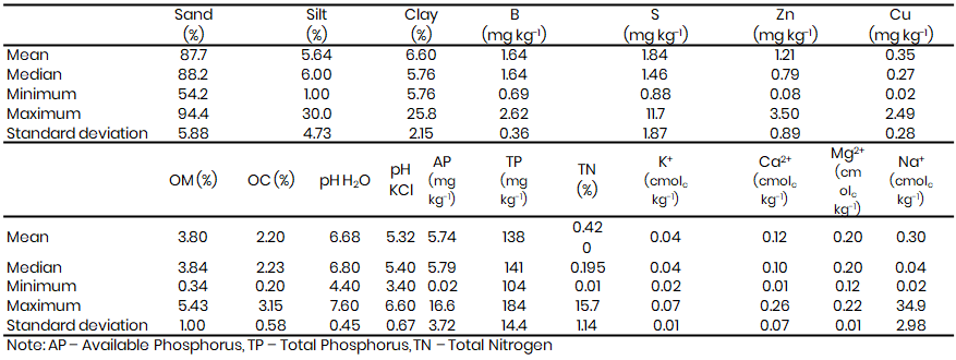
Despite the moderate to high N content in Kwara State’s soils, available phosphorus (AP) levels were generally low, with approximately 95% of soils containing less than 10 mg P kg-1. Only 5% of the samples exhibited higher AP concentrations (>10 mg P kg-1), primarily concentrated in Baruten LGA, a key agricultural region in the northwestern part of the State (Fig. 3). This aligns with previous studies highlighting phosphorus deficiency as a major constraint to crop production in sub-Saharan Africa (Buresh et al., 1997; Sanchez, 2002). Phosphorus is an essential nutrient for root development and energy transfer in plants, and its low availability may significantly limit agricultural productivity. The low AP levels suggest that phosphorus fertilization or the application of rock phosphate amendments may be necessary to improve soil fertility (Kolawole et al., 2024). Additionally, some urban areas exhibited relatively high AP levels, likely due to organic waste accumulation and fertilizer application, supporting findings by previous researchers that human activities significantly influence phosphorus distribution in soils (Yoon et al., 2024).
Soil exchangeable Ca values ranged from 0.01 to 0.26 cmolc kg-1 with a mean value of 0.11 cmolc kg-1. Exchangeable Mg, K and Na were all rated as very low with mean values of 0.20, 0.04 and 0.30 cmolc kg-1 (Table 1, Fig. 3). The very low percentage of variance (<1%) points to the uniformity of these bases however, there are relatively lower K contents within the schist belts in the southeastern part of the State (Fig. 3). Schists are generally known to weather slowly and low in bases. The CEC of the studied soils was predominantly low, with values mostly falling below 10 cmolc kg-1. However, soils derived from basaltic parent materials exhibited moderate CEC values, ranging from 10 to 20 cmolc kg-1. The low CEC values are indicative of limited nutrient-holding capacity, which can lead to rapid nutrient depletion under intensive cropping systems (Havlin et al., 2013). In contrast, moderate CEC values in basalt-derived soils suggest a better ability to retain essential cations such as calcium, magnesium, and potassium, which are critical for plant growth (Brady and Weil, 2016). To mitigate the challenges posed by low CEC, soil management practices such as organic matter incorporation, biochar application, and the use of cover crops can be implemented to enhance nutrient retention and improve soil fertility (Lehmann and Joseph, 2015).
Soil micronutrients in Kwara State ranged from low to moderate concentrations. Copper (Cu) levels varied from 0.024 to 2.49 mg kg-1, with a mean of 0.35 mg kg-1. Extractable zinc (Zn) concentrations were rated as moderate to high, with a mean of 1.21 mg kg-1 (Fig. 3). Boron (B) and sulphur (S) contents ranged from 0.69 to 2.62 mg kg-1 and 0.88 to 11.74 mg kg-1, respectively, classifying them as moderate to high. These micronutrients were not significantly influenced by topography or land use; however, parent material exhibited a significant correlation with B and Zn. The highest concentrations of these micronutrients were recorded in soils derived from granite gneiss and hornblende biotite gneiss in the northern part of the state. Conversely, relatively lower micronutrient contents were found in soils overlying amphibolite and medium to coarse biotite and hornblende granite formations in the south eastern and southern regions.
The coefficient of variation (CV) for soil properties ranged from 0.2 to 207%, with total phosphorus exhibiting the highest variability, highlighting the strong influence of parent material, land use and human activities on soil nutrient distribution. Conversely, pH and organic matter showed the lowest variability (CV <1%), indicating relatively stable conditions across the study area. The stability of pH and OM levels is particularly important, as drastic fluctuations in soil acidity and OM content can have significant implications for nutrient cycling and crop productivity (Loska et al., 2004). These findings underscore the importance of site-specific soil fertility management in Kwara State. Given the heterogeneity in soil properties, tailored soil amendment strategies - such as targeted liming for acid soils, phosphorus supplementation for deficient areas, and OM management to improve nutrient retention - will be essential for optimizing agricultural productivity while maintaining long-term soil health.

Fig. 3. Spatial distribution of geochemical elements
Influence of parent materials on soil properties
Hierarchical clustering analysis provided critical insights into the classification of parent materials based on soil properties (Fig. 4). The results show two primary clusters that distinguish granite-related parent materials from metamorphic and sedimentary-derived materials, although the linear discriminant analysis (LDA) validation of the clusters had a relatively low accuracy of 30.1%. Previous studies suggest that the association of these elements may be interpreted in terms of anthropogenic or geogenic influences (Romic and Romic, 2003; Powlson et al., 2011; Lv et al., 2014; Lorenz and Lal, 2018; Rashid et al., 2023). Available phosphorus, K+ (cmolc kg-1), silt %, sand % and pH were the top variables that influenced the separation of classes. The highest AP and K+ levels were recorded under biotite and hornblende parent materials, with mean values reaching 9.12 mg kg-1 and 0.04 cmolc kg-1 respectively. This differentiation is supported by well-established research indicating that soil genesis is strongly influenced by the mineralogical and geochemical characteristics of parent material (Jenny, 1941; Brady and Weil, 2016).
The first major cluster comprised granite-derived parent materials, including granite gneiss, porphyritic granite (porphyroblastic), and porphyroblastic gneiss. These materials exhibit close relationships due to their similar mineral compositions, which typically include quartz, feldspars, and mica. Granite-derived soils are generally coarse-textured, well-drained, and tend to have low fertility due to their slow weathering rates and nutrient-poor composition (Birkland, 1999). The close clustering of porphyritic granite and porphyroblastic gneiss suggests similar weathering patterns and resultant soil properties, reinforcing prior findings on granite-related pedogenesis (Tucker, 2010). Conversely, the second major cluster consists of metamorphic and sedimentary parent materials such as flaggy quartzite with biotite gneiss, fine-grained flaggy quartzite, banded gneiss, marble, migmatite, and undifferentiated schist. The close association of flaggy quartzite variants suggests a strong influence of quartz content, which is known to contribute to well-drained, low-nutrient soils with high sand fractions (Duchaufour, 1982). Additionally, marble-derived soils, which typically have higher calcium content and improved fertility, exhibit distinct clustering, aligning with research on carbonate-rich parent materials (Schroeder, 2013).
The substantial clustering distance between granite-related and metamorphic/sedimentary parent materials highlights significant differences in soil properties, likely driven by variations in mineral weathering rates, base cation release, and textural composition. This finding is consistent with studies demonstrating the role of lithology in dictating soil fertility, structure, and hydrology (Buol et al., 2011; Amundson et al., 2015). Furthermore, the positioning of other parent materials and undifferentiated schist materials as more distinct entities suggests unique soil characteristics that warrant further investigation. The clustering of parent materials based on soil properties has practical implications for sustainable land management. Granite-derived soils, being inherently nutrient-poor, may require targeted soil fertility amendments, including OM additions and micronutrient supplementation, to support agricultural productivity. In contrast, soils derived from metamorphic parent materials, particularly those associated with schist and carbonate rocks, may offer higher fertility potential but variable drainage properties that necessitate site-specific management strategies (Brady and Weil, 2016). These findings underscore the necessity of incorporating parent material classification into digital soil mapping and precision agriculture frameworks. By integrating this knowledge with geospatial analysis, land managers and policymakers can optimize soil use strategies, enhance crop productivity, and improve ecosystem sustainability in diverse geological settings.
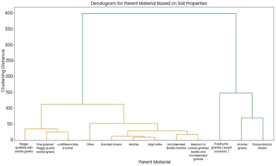
Fig. 4. Clustering of measured soil properties based on parent materials
Land use based clustering and agricultural implications
The cluster analysis based on land use classification provides crucial insights into how different management practices impact soil properties. Three major clusters were shown: Agricultural Land, Forest Land, Urban/Disturbed Land (Fig. 5). The LDA validation of the identified clusters had a relatively low accuracy of 61%, with soil K+ (cmolc kg-1), AP (mg kg-1), sand%, silt%, and pH, in that order, being the top influencing variables of the separation of classes.
Values for these soil quality indicators were consistently higher and comparable under forest and arable land use clusters with mean pH, AP and K+ values ranging from 6.7 to 6.8 (SD: 0.3 – 0.6), 5.4 to 6.2 mg kg-1 (SD: 3.6 – 3.7), and 0.03 to 0.04 cmolc kg-1 (SD: ~0.008) respectively.
The clustering of these soils reflects the cumulative impact of cultivation, fertilizer application, and organic matter depletion due to continuous cropping (Brady and Weil, 2016). The variability within this cluster suggests that while some agricultural soils retain moderate fertility, others are significantly degraded due to overexploitation and soil nutrient mining. This finding aligns with studies on soil degradation in intensively farmed areas, where nutrient imbalances, acidification, and compaction reduce long-term soil productivity (McBratney et al., 2003). Precision nutrient management, including balanced fertilization, crop rotation, and conservation tillage, is essential for restoring soil fertility and ensuring sustainable agricultural production.
Forest soils formed a distinct cluster, characterized by higher AP, K+ and pH values. This clustering highlights the minimal disturbance in forested ecosystems, where continuous litter input and reduced erosion contribute to sustained soil fertility. Forest soils generally exhibit higher microbial activity and C sequestration potential, aligning with findings that undisturbed soils act as major carbon sinks (Six et al., 2002). The separation of forest soils from agricultural soils in the clustering analysis indicates the significant impact of land conversion on soil properties. Deforestation and land clearing for agriculture often result in rapid declines in SOC, increased bulk density, and reduced infiltration capacity, leading to lower productivity and increased vulnerability to degradation (Lal, 2001). These results reinforce the need for agroforestry systems and sustainable land management practices that integrate trees into farmlands to enhance soil fertility and C storage.
Urban soils and those under human disturbances formed a separate cluster, indicative of altered physical and chemical properties possibly due to compaction, pollution, and reduced biological activity. The clustering of urban soils away from natural and agricultural soils suggests significant modifications, including lower AP and altered pH levels. These changes can negatively impact soil health, limiting its suitability for food production and ecosystem services. Restoring urban and degraded soils requires targeted interventions such as organic amendments, remediation techniques, and sustainable land-use planning (FAO, 2015). The use of biochar, compost, and phytoremediation strategies has been shown to improve soil quality in degraded urban landscapes, making them more productive for urban agriculture (McBratney et al., 2003).
The land use and topography-based clustering emphasize the need for differentiated soil management approaches tailored to specific landscape positions and land-use types. Sustainable intensification strategies, including conservation agriculture, site-specific nutrient management, and integrated land-use planning, can help mitigate soil degradation while enhancing productivity. Furthermore, integrating clustering analysis with digital soil mapping and remote sensing can improve the precision of soil fertility assessment, enabling policymakers and farmers to make informed decisions regarding soil conservation, fertilization, and land-use planning (McBratney et al., 2003). These findings support the ongoing transition towards precision agriculture, where soil variability is considered in decision-making to optimize resource use and sustainability.
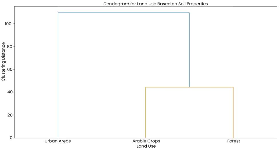
Fig. 5: Clustering of soil properties based on land use
Spatial variability of soil properties across LGAs in Kwara State
The hierarchical clustering of soil properties across Kwara State LGAs reveals distinct groupings based on soil characteristics (Fig. 6), likely influenced by regional variations in parent material, land use, and management practices. LDA validation of the resulting clusters had an accuracy of 78%, and AP, pH, K+ (cmolc kg-1), and sand%, in that order, were the top variables that influenced the separation of classes. LGAs with similar levels of these soil fertility indicators clustered together, highlighting geographical patterns in soil quality. The Baruten, Edu and Kaiama LGA cluster had the highest levels of AP with mean values ranging between 4.5 and 7.7 mg/kg. The trend was also the same for soil pH, with near neutral mean pH values of between 6.4 and 6.8. Soil mean K+ values ranged between 0.03 and 0.04 cmolc kg-1. This clustering can be attributed to differences in soil formation factors such as climate, topography, and human activity (Jenny, 1941). Understanding these regional soil similarities is essential for tailoring site-specific soil management practices to optimize crop productivity (Brady and Weil, 2016).
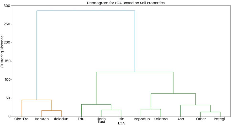
Fig. 6: Clustering of LGAs based on measured soil properties
Topography based clustering of soil properties and its influence on soil fertility
The hierarchical clustering based on topography demonstrates a clear differentiation of soil properties across landscape positions (Fig. 7). LDA validation of the clusters had a less-than-average accuracy of 43%. Available phosphorus, K+ (cmolc kg-1), sand%, silt%, and clay%, in that order, were the top variables with the most influence on class separation. Soils from lowland and gently undulating terrains formed a distinct cluster, having the highest levels of AP reaching up to 16.56 mg kg-1. This trend indicates similarities in texture, OM content, and moisture retention, indicative of areas typical to accumulate fine-textured sediments, organic materials, and nutrients transported from upslope positions, resulting in higher soil fertility and productivity (Lal, 2001; Brady and Weil, 2016). Conversely, soils on steeper slopes and hilly landscapes clustered separately, reflecting increased susceptibility to erosion, leaching, and reduced OM accumulation.
In sloping terrains, the movement of water and soil particles due to runoff leads to the selective removal of finer particles and OC, often resulting in coarser, nutrient-poor topsoil with limited water-holding capacity (FAO, 2015). This clustering pattern is consistent with previous findings that erosion-prone soils in hilly regions require specific soil conservation strategies, such as contour plowing, mulching, and agroforestry, to enhance soil stability and fertility (Lal, 2001). The variation in soil properties with topography underscores the need for site-specific management, ensuring that erosion-prone areas receive adequate soil amendments and cover cropping to mitigate nutrient loss and improve soil structure. Moreover, soil moisture regimes differ significantly with topography, influencing plant-available water and microbial activity. Lowland soils, often classified within the same cluster, generally exhibit higher moisture retention due to limited drainage, making them more suitable for water-demanding crops. In contrast, well-drained, sloping soils tend to have lower moisture content, necessitating irrigation or drought-resistant cropping strategies. These findings align with studies indicating that topographically driven soil moisture variability affects nutrient cycling, root growth, and overall soil health (Six et al., 2002).
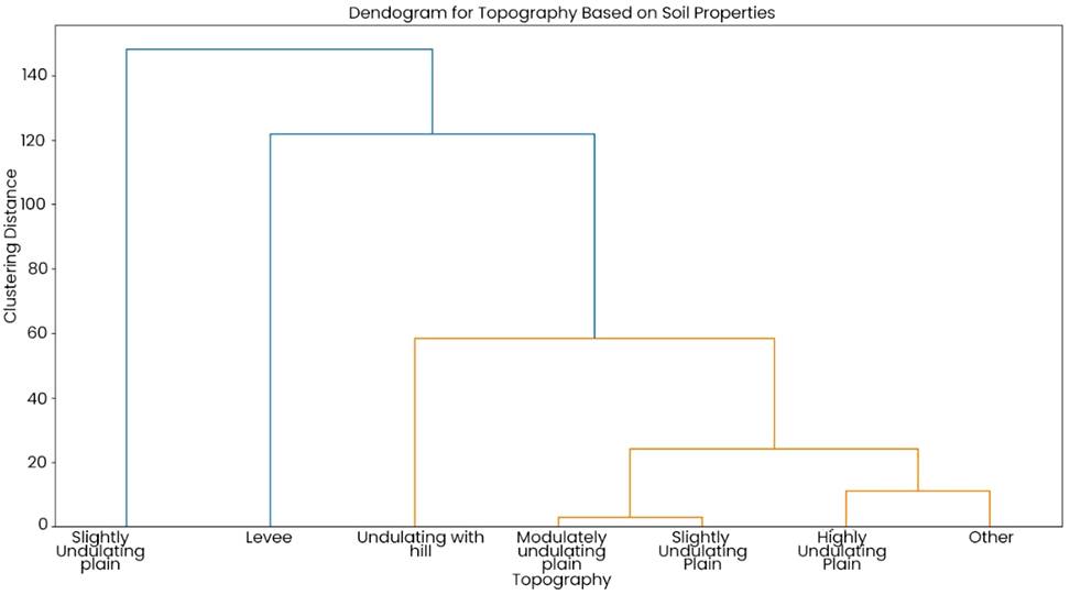
Fig. 7: Topography cluster classes based on soil properties
General relationships between soil physical and chemical properties in the study area
Correlation analysis of soil properties provides valuable insights into the relationships between soil properties, geochemical element availability and soil fertility under land uses and soil parent materials (Fig. 8). A strong positive correlation between sand content and soil pH (r = 0.64) suggests that sandy soils tend to have higher pH levels, likely due to their lower OM content and CEC, which reduces acid buffering capacity (Brady and Weil, 2016). In contrast, finer-textured soils with higher silt and clay content display weaker or negative correlations with pH, reflecting a tendency for these soils to retain more OM and acidic cations, which lower pH (Fageria et al., 2011). This highlights the significant role of soil texture in influencing pH, which in turn affects nutrient availability, a key consideration for land management practices such as lime application and crop selection.
The moderate positive correlation between OC and pH (r = 0.24; p= .001) supports the notion that soils with higher OM content can buffer pH changes through organic acid release and metal complexation (Lorenz and Lal, 2022). Additionally, OC shows positive correlations with key nutrients such as K, Ca, Mg, and B, indicating that OM enhances nutrient retention through improved CEC and nutrient mineralization (Pierzynski et al., 2005). Although the relationship between OC and available phosphorus is relatively weak (r = 0.12; p=.048), it nonetheless underscores the role of organic matter in maintaining phosphorus availability, which is influenced by other factors such as pH and clay content (Havlin et al., 2013).
These findings emphasize the importance of managing organic matter to improve soil fertility, particularly through practices like conservation tillage and organic amendments. Soil pH also plays a crucial role in determining nutrient availability, as evidenced by its positive correlations with K (r = 0.42; p = .001), Ca (r = 0.19; p = .001), and Mg (r = 0.68; p=.001). This suggests that higher pH levels promote the availability of these base cations, likely due to reduced leaching and increased solubility at neutral to slightly alkaline pH levels (Marschner, 2012). Conversely, micronutrients such as Zn and Cu exhibit weaker positive correlations with pH, reflecting the complex interactions that govern micronutrient availability, which can decrease in highly alkaline soils (Schlesiger and Bernhardt, 2020). These correlations highlight the need for careful pH management to balance nutrient availability, particularly when applying lime to acidic soils, to ensure that macronutrient uptake is optimized without compromising micronutrient availability.
The positive relationship between clay content and TN (r = 0.28; p= .001) indicates that clay-rich soils tend to retain more N due to their higher CEC and water-holding capacity, which prevents N leaching and promotes OM accumulation (Schweizer et al., 2021).
This underscores the importance of clay content in maintaining soil fertility and highlights the need for land management practices that prevent nutrient depletion, particularly in clay-rich soils subjected to intensive agriculture. Furthermore, the correlations between macronutrients and micronutrients, such as the strong positive relationship between Cu and Zn (r = 0.45; p= .001), suggest that these elements share similar pathways of availability, possibly through parent material weathering or OM mineralization (Fageria et al., 2011). This interdependence implies that nutrient management strategies must consider the co-movement of nutrients to prevent imbalances and deficiencies.
The correlation analysis reveals that soil texture, OM, and pH are critical factors influencing nutrient availability in soils. Sandy soils are associated with higher pH levels, which improve the availability of base cations but may limit some micronutrients. Organic matter plays a central role in nutrient retention, while clay-rich soils show a greater capacity to retain N. These findings emphasize the need for tailored nutrient management strategies that account for the specific properties of soils under different land uses and parent materials. Sustainable practices that enhance organic matter and maintain optimal pH levels are essential for improving soil fertility and crop productivity (Brady and Weil, 2016; Lorenz and Lal, 2022).
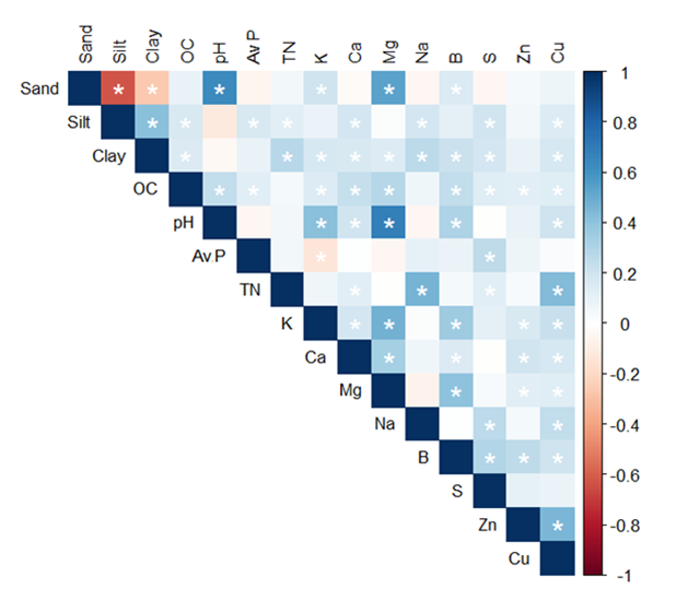
Fig. 8: General trends between analysed soil properties in Kwara State
Conclusion
Findings from this study indicate that the soils of Kwara State are inherently low in fertility, with both macronutrient and micronutrient deficiencies widespread across different parent materials, land use types, and topographical features. The hierarchical clustering analysis of soil properties based on parent materials, topography and land use reveals significant spatial and land-use-driven variations in soil fertility across Kwara State LGAs. Parent material influenced soil exchangeable cation, mainly potassium and pH levels. Topography-based clustering highlights the influence of landscape position on soil nutrient distribution, organic matter content, and erosion susceptibility. Soils in lowland areas exhibit higher fertility due to sediment and organic matter accumulation, while those on steep slopes are more prone to erosion and nutrient depletion, necessitating targeted soil conservation strategies such as contour farming and agroforestry.
Similarly, land-use-based clustering underscores the impact of human activities on soil quality. Agricultural soils, though productive, show varying degrees of degradation due to intensive cultivation and nutrient mining, reinforcing the need for sustainable soil management practices, including balanced fertilization and conservation tillage. In contrast, forest soils demonstrate higher soil OC content, emphasizing the ecological benefits of maintaining tree cover and implementing agroforestry systems. Urban and disturbed soils, which exhibit altered chemical and physical properties, require remediation interventions such as organic amendments and phytoremediation to restore fertility and functionality.
Given the significant correlation between soil pH and nutrient availability, soil acidity management should be prioritized to enhance nutrient retention and uptake in the State. For sustainable crop production, targeted soil fertility management strategies are essential. The application of balanced fertilizers, coupled with organic amendments, can help restore nutrient levels and improve soil productivity. Additionally, site-specific fertilizer recommendations based on parent material classification could enhance nutrient-use efficiency. Given the level of uniformity of soil mineralogy despite varying geological formations, future research should focus on detailed nutrient mapping and precision agriculture techniques to optimize soil management practices in the region.
These findings have critical implications for agricultural soil fertility assessment and management. By integrating clustering analysis with precision agriculture techniques, policymakers, researchers, and farmers can develop more effective site-specific soil fertility management strategies that optimize productivity while minimizing environmental degradation. Furthermore, digital soil mapping and remote sensing can enhance soil monitoring efforts, ensuring the long-term sustainability of agricultural systems. Ultimately, recognizing the complex interactions between landscape position, land use, and soil properties is essential for improving soil health, enhancing crop yields, and fostering resilient agroecosystems in the face of climate change and land degradation challenges.
Acknowledgements
The contributions of all authors are acknowledged. The authors also acknowledge and thank the Nigerian Tertiary Education Trust Fund (TET Fund) for supporting this study via Research Grant No. TETF/DR&D/CE/NRF2021/SETI/AFS/00372. Microsoft Word in-built proofreading and Grammarly free version were used for writing assistance (spelling, grammar correction, and summarising) and language improvement. The authors take responsibility for all outputs of assistive writing tools and the manuscript's content.
Competing interests
The authors declare that there are no known conflicts of interest.
References
Adepetu, J. A., Nabhan, H., & Osinubi, A. (1996). Simple soil, water, and plant testing techniques for soil resource management. FAO Soil Bulletin.
Akinrinde, E. A., & Obigbesan, G. O. (2000). Evaluation of the fertility status of selected soils for crop production in five ecological zones of Nigeria. In Proceedings of the 26th Annual Conference of Soil Science Society of Nigeria (pp. 279–288).
Alloway, B. J. (1990). The origin of heavy metals in soil. In B. J. Alloway (Ed.), Heavy metal in soils (pp. 29–39). John Wiley and Sons.
Amundson, R., Berhe, A. A., Hopmans, J. W., Olson, C., Sztein, A. E., & Sparks, D. L. (2015). Soil and human security in the 21st century. Science, 348(6235), 1261071. https://doi.org /10.1126/science.1261071
Bationo, A., Waswa, B., Kihara, J., & Kimetu, J. (2007). Advances in integrated soil fertility management in Sub-Saharan Africa: Challenges and opportunities. Springer. https://doi.org /10.1007/978-1-4020-5760-1
Birkeland, P. W. (1999). Soils and geomorphology (3rd ed.). Oxford University Press.
Brady, N. C., & Weil, R. R. (2016). The nature and properties of soils (15th ed.). Pearson Education.
Bray, R. H., & Kurtz, L. T. (1945). Determination of total organic and available forms of phosphorus in soils. Soil Science, 59(1), 39–45. http: //dx.doi.org/10.1097/00010694-194501000-00006
Bremner, J. M., & Mulvaney, C. S. (1982). Nitrogen total. In A. L. Page, R. H. Miller, & D. R. Keeney (Eds.), Methods of soil analysis. Part 2 (pp. 595–624). ASA. https://doi.org /10.2134/agronmonogr9.2.2ed.c31
Buol, S. W., Southard, R. J., Graham, R. C., & McDaniel, P. A. (2011). Soil genesis and classification (6th ed.). John Wiley & Sons.
Copyright
Open Access: This article is licensed under a Creative Commons Attribution 4.0 International License, which permits use, sharing, adaptation, distribution and reproduction in any medium or format, as long as you give appropriate credit to the original author(s) and the source, provide a link to the Creative Commons license, and indicate if changes were made. The images or other third party material in this article are included in the article’s Creative Commons license, unless indicated otherwise in a credit line to the material. If material is not included in the article’s Creative Commons license and your intended use is not permitted by statutory regulation or exceeds the permitted use, you will need to obtain permission directly from the copyright holder. To view a copy of this license, visit http://creativecommons.org/licenses/by/4.0/.

